

Several years before I arrived at U of T for graduate school, I had left my hometown in Philadelphia and begun travelling the world: studying development projects in Sri Lanka, taking courses in classical history and archeology in Italy, teaching in England and making art in Portugal.
Boastful of my sojourns, I placed pins on a broad world map marking each new destination that I had “conquered.” But I also became intrigued by the idea that this map wouldn’t exist if there hadn’t been bold explorers who first headed out into the unknown and recorded what they saw.
Alex Jones, a classics professor I met when I arrived at U of T in 1988, must have sensed this curiosity when he told me: “The history of cartography – that’s the subject for you.” And so, during my studies at U of T’s Institute for the History and Philosophy of Science and Technology, I had the opportunity to carry out several years of research on the history of maps and exploration in the medieval period.
Early maps are pictures of lands and seas, but they are also pictures of how earlier civilizations perceived the world. They did so in ways often very different from us, building maps based on exploration but also on myth, hearsay, speculation.
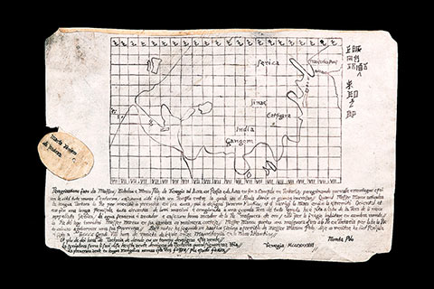
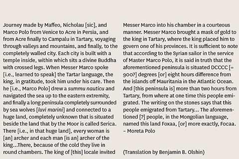
Some years after graduation, I tracked down a set of obscure early maps and texts owned by a private collector. These maps intrigued me because of their background. They had been brought to the U.S. by an Italian immigrant named Marcian F. Rossi, and were now held by one of his descendants. Rossi had traced his lineage in Italy back to an admiral who had known Marco Polo, the Venetian merchant who trekked the length of Asia between 1271 and 1295.
The maps had been discussed in an article from the 1940s, but no detailed study had been done, so I seized the opportunity. Thus began years of investigation and analysis, including the arduous task of translating obscure bits of Latin, medieval Italian and even Chinese on the documents.
“I have not told half of what I saw.” – Marco Polo, in his Books of the Marvels of the World
The documents themselves, done in ink on vellum, recount a previously unknown history of the famous Polo. One text speaks of a “land of frost” and “sea lions,” and refers to the far reaches of northeast Asia, which is also what some of the maps apparently depict – a region not found in the traditional Polo narrative. This same text also speaks of a “remote peninsula washed by the seas, where the people, because of the extreme cold, live in caves…” Such descriptions, and some renderings on the maps themselves, are suggestive of early knowledge of the western shores of North America, some two centuries before Columbus. The documents also imply a charting of the northern Pacific Ocean and maybe even part of Alaska 500 years before the Russians first sent expeditions there. The quantity of the materials (some 14 maps and texts in all), and the number of connections within and among them, added to the intrigue of the case and the complexity of the investigation.
With the recent publication of my book, The Mysteries of the Marco Polo Maps (2014), a much wider audience has the chance to understand the beauty and complexity of these and other maps, and the role that merchants and explorers such as Marco Polo had in expanding our knowledge of distant lands. I like to think that somehow my own travels – which, after graduate school, finally included several years in Asia – are an echo of Polo’s curiosity about the world beyond his humble origins.
Benjamin B. Olshin (MA 1990, PhD 1993) is a professor at the University of the Arts in Philadelphia.
Recent Posts
U of T’s 197th Birthday Quiz
Test your knowledge of all things U of T in honour of the university’s 197th anniversary on March 15!
Are Cold Plunges Good for You?
Research suggests they are, in three ways

Work Has Changed. So Have the Qualities of Good Leadership
Rapid shifts in everything from technology to employee expectations are pressuring leaders to constantly adapt