

You can find practically anything using Google, so why not the whereabouts — and health — of the trees in your neighbourhood?
It’s now possible, thanks to a program designed to protect and sustain urban forests. Although local governments take care of trees in parks or on streets, the vast majority are found in people’s yards. Homeowners are responsible for sustaining the trees on their property, but all residents suffer when urban trees decline.
That’s why Andrew Kenney, a U of T forestry professor, created Neighbourwoods. The program enlists volunteers to measure and classify all the trees in their community and then develop a strategy for caring for and, eventually, replacing them.
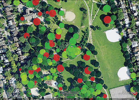
Volunteers collect information about the size, type, health and location of trees, which Kenney’s team enters into a database, analyzes and now shares on Google Earth (with the community’s permission). Toronto’s Trinity Bellwoods Park is shown at right.
Neighbourwoods groups have formed in downtown Toronto and across Ontario. Kenney says the next step is to develop strategies for urban forest renewal, and to estimate the benefits in terms of air quality, storm water management and lower carbon emissions. These calculations “make it clear why we’re doing this in the first place,” he says.
Recent Posts
People Worry That AI Will Replace Workers. But It Could Make Some More Productive
These scholars say artificial intelligence could help reduce income inequality
A Sentinel for Global Health
AI is promising a better – and faster – way to monitor the world for emerging medical threats

The Age of Deception
AI is generating a disinformation arms race. The window to stop it may be closing