
What makes a city “smart”? For a tech firm such as Microsoft or IBM, it’s about how to collect and use urban data to make smarter decisions, says Mark Fox, a U of T professor of urban systems engineering. “But from a social sciences perspective, it’s more about a city’s ability to use the knowledge of its employees, citizens and companies to do things better.” Mixing data with human expertise isn’t simple, but if it’s done well, it goes a long way toward turning the ideals of smart city planning into reality.

Improved Air Quality in Beirut
You don’t have to spend much time in Beirut to know that air pollution is a problem. But just how bad is it – and what’s the solution?
Marianne Hatzopoulou, a professor in U of T’s department of civil and mineral engineering who holds the Canada Research Chair in Transportation and Air Quality, has been working with a professor from the American University of Beirut to study air quality across the Lebanese capital. She and Prof. Ibrahim Alameddine are using low-cost sensors to measure carbon monoxide, nitrogen dioxide, coarse particulate matter and other pollutants at nearly 70 sites across the city.
They match their data with traffic maps, housing density, location of factories and power stations, and other local information to identify air pollution hot spots and where people are most at risk. The goal is to use the information to develop policies that will lead to better health for the city’s residents.
For example, policymakers might change building codes in high-pollution areas to require greater attention to indoor air quality or enact stricter regulations on vehicle emissions. “Transportation planning is not just about congestion or traffic, but also about air-pollution exposure and quality of health,” she says.
Better Transit for Montevideo
Montevideo, Uruguay, is a city of more than a million people, and a growing commercial centre in South America. But its future success will depend at least in part on developing a modern, efficient public transit system.
Eric Miller, a U of T professor in civil and mineral engineering, is working with the city to eventually create simulations that will help planners decide where to place bus lines, when and how to add rapid transit such as express buses or light rail – and even how much to charge for tickets.
His detailed simulations require extensive data, which Montevideo happens to have. The city uses smart-card payments for transit, and has a high penetration of cellphone usage, which can help track how people move around the city.
Miller, who is director of U of T’s Transportation Research Institute, has done simulations of Toronto and other Canadian cities, but he cautions against assuming that what works in Canada will succeed elsewhere. Though his work is data-driven, his research also involves learning about local politics, culture, history and geography to ensure he’s developing smart solutions that will work for that city.
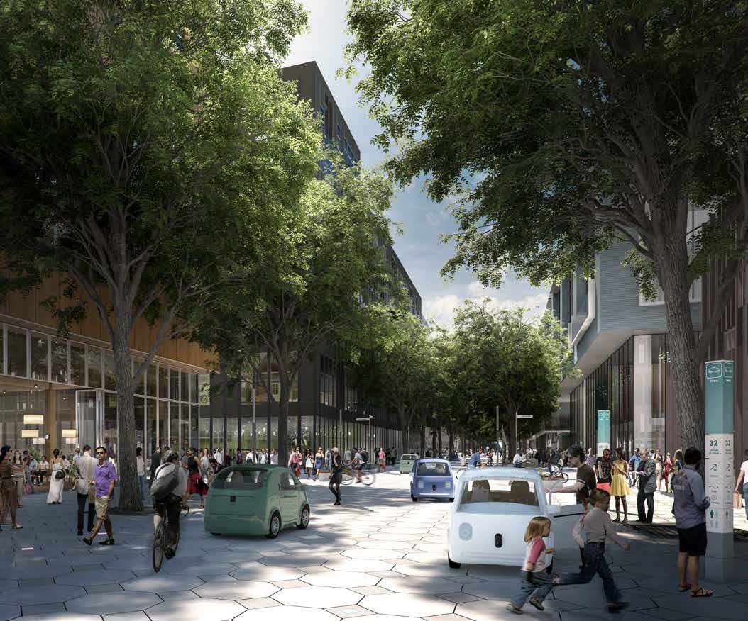
Sidewalk’s Lab for Urban Innovation
Sidewalk Labs, a subsidiary of Google’s parent company, Alphabet, is working with Waterfront Toronto to build an experimental neighbourhood that incorporates many elements of smart-city planning.
Nearly five hectares of industrial land on Toronto’s eastern waterfront will become a new community served by autonomous transport, buildings that can be quickly reconfigured for different uses, robot trash pickup and an ultra-efficient energy grid powered by renewable electricity. The project has attracted the attention of many U of T professors who are interested in contributing ideas and in studying the results. Initial plans are expected to be approved by the end of 2018.
The project has generated controversy, with some people uneasy about the types and amount of data Sidewalk Labs will collect. But Mark Fox, a professor of urban systems engineering at U of T, is still excited about the plan. “What is really smart here is they identified these great ideas that have been around for a while and brought them all together in this one location. It’s an amazing experiment.”
Choosing the Right Recreation Facilities
Even within Canada, a seemingly straightforward issue such as encouraging exercise varies from city to city. What works in snowy, sunny Edmonton might not work in warm, rainy Vancouver.
A database called the Canadian Active Living Environments (Can-ALE) already provides researchers and planners with estimates of the potential for physical activity for neighbourhoods across the country.
Jeffrey Brook, a professor at U of T’s Dalla Lana School of Public Health, is also the scientific director of the Canadian Urban Environmental Health Research Consortium, which hosts a platform for research on urban form and human health. The platform allows researchers to drill down into the Can-ALE database by demographics, climate and other variables. It can help guide decisions on the location of parks, playgrounds and other public facilities that encourage physical fitness.
In its third year, the consortium makes it easier for researchers to collect and share data with planners to make cities healthier places to live, Brook says.
Most Popular

Fuel for Dreams
Six students share how U of T financial support made university more affordable – and what became possible as a result Read More
Religion Versus the Charter
Canada’s commitment to multiculturalism is being tested in new and unexpected ways Read More

Advance Justice for Indigenous Peoples
A decade after the Truth and Reconciliation Commission’s Calls to Action, U of T experts weigh the gains, the gaps and the next steps Read More